
Corporate Address
Lynchburg, VA 24502
Experience and Qualifications of Amerimark Utility Locating
Amerimark Utility Locating, LLC
21430 Timberlake Road, PMB 304
Lynchburg, VA 24502
6 Employees
DUNS: 966357175
SSC: S314552-3
SWAM: 691148
NAICS Codes:
561990 (Utility Locating)
541360 (Geophysical Services)
About Amerimark
Amerimark Utility Locating, LLC is a SWaM certified utility locating company established in 2010. We offer comprehensive, professional subsurface investigation services in accordance with ASCE 38-02 Stand Guidelines for the Collection and Depiction of Subsurface Utility Data for design, excavation and construction projects. Amerimark is capable of providing any of the following subsurface investigation services:
Utility CAD Mapping
Utility Research
Electronic Utility Markers
Septic System Locating
Storm Box Clean-Out
Test Hole Excavation
Pipe Inspection
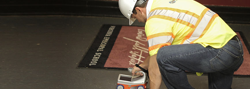
GPR – Concrete Inspection
Leak Detection
Electrical Fault Location
Utility As-Built Drawings
Plastic and Concrete Water Line Locating
Underground Tank Detection
Valve Box Detection / Clean-Out
Information Databases/GIS
Non Conductive Utility Designation
GPR Utility Location
Reinforcement Verification
Video Pipeline Inspection
Manhole Cover Locating and Cleaning
Organizational Memberships:
National Utility Locating Contractors Association
Underground Utility and Leak Locators Association
National Utility Contractors Association
Common Ground Alliance
Miss Utility Virginia
North Carolina 811
South Carolina 811
Certifications:
Sensors and Software GPR
OSHA 30-Hour Construction
OSHA 40-Hour HAZWOPER
CPR/First AID TWIC
Driving Safety
HAZMAT Certification
ISO/Railcar Inspection
Government Security Clearance
Lean Six Sigma
Confined Space Entry
Our Clients consist of State, Local, Federal, Industrial, Municipal and Private Customers. We use the most advanced Electromagnetic line locating and Ground Penetrating Radar (GPR) technology available.
Our Mission is to provide the Contractor, Excavator, Civil/Design Engineer or Surveyor with Sub-surface Utility Engineering (SUE) or Private Utility Locating and Mapping services in order to avoid any potential hazards or structural damage when designing, digging or excavating. Our goal is to help make your project a safe and profitable one.
Amerimark provides private underground utility-line locating and mapping services in accordance with ASCE Standard 38-02 – The Standard Guideline for the Collection and Depiction of Existing Subsurface Utility Data, Quality Level “B” prior to excavation and for design-build specifications.
Experience Categories:
VDOT / Interstate
River/Bridge Crossings
Cellular Tower Sites
Stadiums / Football Fields
Education / K-12 / University
Engineering Firms
Food Manufacturers & Processors
Radio Station Sites
Environmental Services Locating
Municipalities
Equipment and Methods:
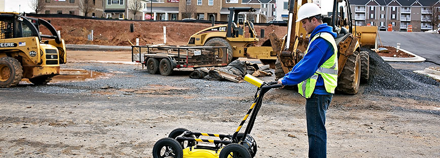
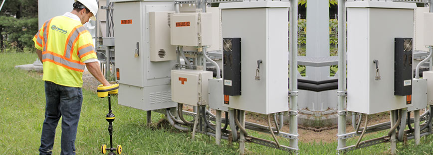
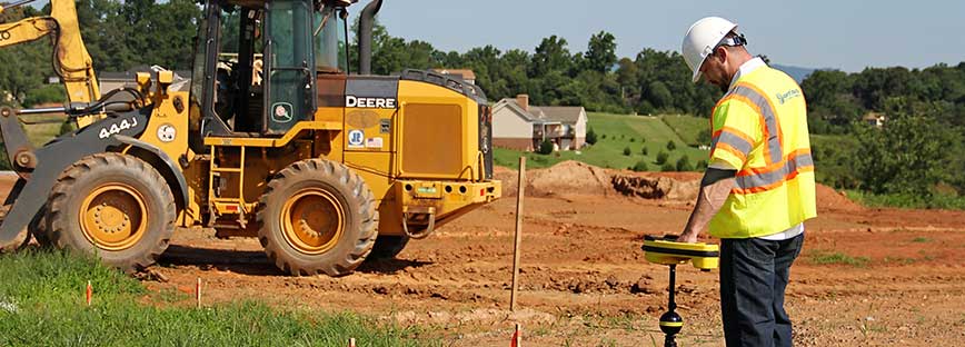
Amerimark Utility Locating, LLC provides private utility locating services using geophysical methods including Electromagnetic {EM) scanning and Ground Penetrating Radar {GPR). These services provide the horizontal designation of buried utilities in accordance with the ASCE 38-02: Standard Guidelines for the Collection and Depiction of Subsurface Utility Data for any engineering, design, construction or excavation project. In accordance with this standard (ASCE 38-02), geophysical services are used to provide Quality Level B data. Quality Level A data which includes precise location, pipe size and elevations can only be obtained through test holes (vacuum excavation services).
Amerimark inventories include multiple EMI Technologies and GPR in the utility scan investigation to include:
The Mag Horn, Model 450 is a stand-alone locator specifically designed to detect ferrous (iron) objects, such as property pins, curb boxes, manhole and valve covers. It responds to the difference in magnetic field strength detected by two sensors in the locator. The tone from the speaker changes in pitch to indicate the presence of a ferrous object.
The Pipehorn Series 800-HL is a state-of-the-art, dual-frequency, pipe and cable locating system designed for the professional with complex locating jobs. The 800-HL is two tools combined into one for attacking any locating job. It can operate as a low-frequency conductive locator and as a high-frequency inductive or conductive locator. This equipment is used to locate and trace all types of buried or concealed conductors such as: pipe, cable, tracer wire, traceable fiber optics, or even sewer snakes or fish tape inserted into non-conductive pipe. The 800-HL has an audible response as well as a visual response to help verify the located utility and to provide an estimated depth.
The SR-60 Seek Tech operates in three distinct modes. They are:
- Active Line Trace Mode, used when a chosen frequency can be put onto a long conductor using a Line Transmitter, for locating conductive pipes, lines, or cables.
- Passive Trace Mode, used for tracing electrical lines that are already carrying 60 Hz current (U.S.), 50 Hz current (Europe), or radio frequencies.
- Sonde Mode, used for locating Sondes in pipes, conduits, or tunnels that are non-conductive or cannot otherwise be traced.
Trimble GEO 7X GPS Mapping Handheld Feat. Terrasync enables the user to map located utilities and provide within 2mm accuracy, the GPS Coordinates of the utility which can then be added to maps, blueprints and CAD files if necessary.
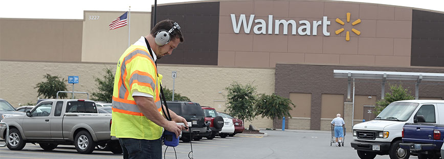
The COW-MAC Mini Leak Detector enables the user to quickly and efficiently find costly leaks on site. Many substances are able to be located including water and fuels.
Professional Plus LD-12 Leak Detector enables the user to quickly and efficiently find costly water leaks on site.
When mapping underground utilities or providing utility clearance activities at any site, Amerimark will utilize various geophysical equipment and methods to search for known and unknown utilities that may exist. Electromagnetic (EM) scanning is the traditional locating method utilizing various EM equipment and methods including conductive, inductive and passive methods of tracing to designate the location of conductive utilities. EM can also be used to trace plastic or other nonconductive utilities only when the utility can be accessed (such as in a manhole or clean-outs) in order to insert a transmitter into the pipe for tracing purposes. This is often done with a sonde or a tone-able duct redder to locate sewer and storm pipes made of concrete, clay, terra cotta or plastic, but the length of the trace will be limited to the distance that the transmitter or redder can be pushed through the pipe.
EM will first be utilized to identify and trace all known utilities both within and adjacent to the survey area. Known utilities include utilities that are identifiable by visually observing the survey area to identify all aboveground indicators of buried utilities including valves, hydrants, manholes, inlets, boxes, and any other underground utility structures. Additionally, existing records will be researched for indications of buried utilities. Access to adjacent buildings is required in order to identify where utilities enter and exit those buildings. Amerimark technicians will impress signals upon all of the utilities inside adjacent buildings while tracing the area in which the survey will occur. Amerimark will search for unknown utilities by performing passive scan, inductive scans and split-box scans (with EM) using a grid pattern throughout the work area. The following equipment will be utilized:
Ground Penetrating Radar is utilized with the Sensors and Software Utility SmartCart to designate both conductive and non-conductive utilities. GPR is used to trace underground utilities not trace-able with traditional EM methods, to verify utility locations designated with EM, and also to search for additional unknowns by performing a grid survey throughout the survey area. Equipment with various antenna frequencies is utilized to achieve the depth penetrations necessary for the soil conditions of the site.
Underground utility depths can be investigated and recorded by the geophysical crew as part of the Level B (geophysical study) but cannot be guaranteed in any way in accordance with ASCE 38 -02. This is done by taking depth readings along the route of the utility and evaluated for consistency. Depth readings are crosschecked between EM and GPR instruments to determine reliability so the most reliable information gets recorded. Precise utility elevations require vacuum excavation services to obtain Quality Level A Utility Data in accordance with the standard ASCE 38-02. This involves physical exposure of the utility within a test hole using air knife and vacuum methods. All utility information including size, type, material, condition, horizontal location and precise elevation is documented in accordance with ASCE 38 -02. Amerimark owns the following equipment:
Traditional GPS survey techniques are available for use when CAD Mapping underground utilities for site documentation. The following tasks are typical for CAD Mapping services:
- Establish horizontal and vertical survey control at the site suitable to permit the mapping of underground utilities to be inserted into existing mapping (if available)
- Field locate all underground utility designations
- Review the map to show the positions of surface indications of underground utilities such as manholes, water valves, etc.
- Establish elevations on the rims of manholes and other utility structures
- Provide files in a format with AutoCAD showing the mapped facilities
Key Personnel
Garrett Simpkins, Managing Director
Garrett has spent 12 years in the commercial and residential plumbing industry leading maintenance and install crews, 10 years in the telecommunications field leading crews on daily installations and managing productivity on site before getting into the Private Utility Locating field, giving him knowledge on the various types of underground utilities that we deal with here at Amerimark. Garrett has 6 years of expert experience in all fields related to locating/GPR/ leak detection field with Amerimark. As the Director of Amerimark, Garrett handles all billing, redlines, quotes and recommendations associated with new business.
- Member National Utility Locating Contractors Association
- Member Underground Utility and Leak Locators Association
- Member National Utility Contractors Association
- Member Common Ground Alliance
- OSHA Certified, 30 Hour Construction / 40 Hour HAZWOPER
- Precision Utility Locating Training Course, Dewey, Arizona
- Sensors and Software GPR Training
Corey F. Evans, Director of Operations/Safety Coordinator
Corey spent 10 years in the United States Marine Corps. as an Aviation Ordnance Technician. After being discharged, Corey joined the Amerimark team. While in the military Corey was certified as an Instructor while on Instructor Duty then as an Instructor Evaluator. Corey brings many things to our team at Amerimark with a few being Quality Assurance Safety Observer Qualifications, HAZMAT Certifications, Explosives Qualifications and Government Security Clearance. Corey is an experienced and capable manager and locator who will strive for customer satisfaction, safety and accuracy. Corey handles all of the training requirements for Amerimark employees, ensures site safety at all locations and is our project manager on all operations.
- Bachelor of Arts Degree, Emergency and Disaster Management, American Military University
- OSHA Certified, 30 Hour Construction / 40 Hour HAZWOPER
- Quality Assurance Safety Observer (QASO)
- Confined Space Certified
- HAZMAT/Explosive Driver
- Railcar and ISO Inspection Officer
- Journeyman, Aviation Ordnance (North Carolina, Florida and Nationally through USMAP)